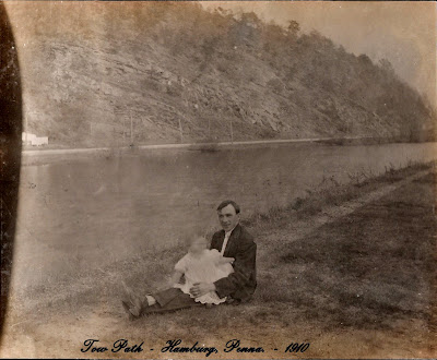
+father+%26+son.jpg) Another photo from the Tow Path stroll. The path itself here looks a lot less used than in the earlier photos. You get a nice view of the hillside across the river. I think that's a road running along the other bank as well, complete with telephone poles. And a building or two at the far left - but not enough to be able to identify it.
Another photo from the Tow Path stroll. The path itself here looks a lot less used than in the earlier photos. You get a nice view of the hillside across the river. I think that's a road running along the other bank as well, complete with telephone poles. And a building or two at the far left - but not enough to be able to identify it.Tuesday, May 29, 2007
53. Tow Path
+father+%26+son.jpg) Another photo from the Tow Path stroll. The path itself here looks a lot less used than in the earlier photos. You get a nice view of the hillside across the river. I think that's a road running along the other bank as well, complete with telephone poles. And a building or two at the far left - but not enough to be able to identify it.
Another photo from the Tow Path stroll. The path itself here looks a lot less used than in the earlier photos. You get a nice view of the hillside across the river. I think that's a road running along the other bank as well, complete with telephone poles. And a building or two at the far left - but not enough to be able to identify it.
Subscribe to:
Post Comments (Atom)

2 comments:
With the canal about even with the road and the steep bluff right adjacent I'd hazard a guess this is just north of modern I-78 and south of the Mountain Rd along Port Clinton Avenue. The hillside looks much the same today but the canal level is drained down about 6 feet. The banks of the canal are grown in with some mature trees now. There are still buildings just to the left in that spot; if it's where I think it is. mick.......
I like the rock strata of the hillside. Not level with the ground at all. Which makes me think there must have been some nasty upheavals here a long, long time ago.
Post a Comment